
Routes links:
7.6 mile route 21 mile route
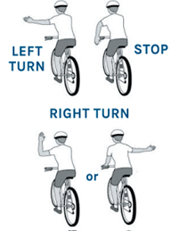
Both routes are on open roads with possibly heavy traffic. Safety is our top concern. Please be comfortable riding near cars and in traffic. Here is a brief review of hand signals and verbal commands.
Hand signals
Verbal Commands
We communicate with each other on rides using verbal commands. Using these safely and correctly is the responsibility not only of the ride leader, but of each participant in the ride.
Car Back! – Car is approaching from the back. Ride in single file!
Car Up! – Car approaching from the front. Be aware!
Car Left/Right – Use at intersections to make other riders aware that a vehicle is approaching from that direction.
Clear – Use at stop signs and yields to make follow on riders aware that there are no vehicles present at that moment. You should make sure it’s safe to go, and, if it’s safe for riders behind you, call Clear for them. It is not a license to disregard road signs.
Door - Use when riding along parked cars. Watch all cars that are parked & if you see someone in the driver's seat call out “door” to warn of door opening at any time.
On Your Left – Use every time you pass a rider to make them aware of your intention to pass.
Slowing – Use along with the hand signal when applying the brakes.
Stopping – Use along with the hand signal to make follow-on cyclists aware that you intend to come to a complete stop.
Tracks: Use when approaching railroad tracks. Always cross RR tracks at a 90 degree angle to avoid getting tires trapped in the tracks